![](/images/other/stat-length.png)
![Excursión A pie Bad Gottleuba-Berggießhübel - Gelber Punkt Bahratal - Photo](https://media.geolcdn.com/t/1900/400/08477713-b79e-498c-b24d-3abebd747575.jpeg&format=pjpeg&maxdim=2)
Gelber Punkt Bahratal
SityTrail - itinéraires balisés pédestres
Tous les sentiers balisés d’Europe GUIDE+
![Longitud](/images/other/stat-length.png)
Longitud
9,5 km
![Altitud máxima](https://static1.geolcdn.com/siteimages/upload/files/1508320355ic_sort_altitude_max_24dp.png)
Altitud máxima
521 m
![Desnivel positivo](https://static1.geolcdn.com/siteimages/upload/files/1508320355ic_sort_den_pos_24dp.png)
Desnivel positivo
308 m
![Km-Effort](/images/other/stat-length.png)
Km-Effort
13,3 km
![Altitud mínima](https://static1.geolcdn.com/siteimages/upload/files/1508320355ic_sort_altitude_min_24dp.png)
Altitud mínima
401 m
![Desnivel negativo](https://static1.geolcdn.com/siteimages/upload/files/1508320355ic_sort_den_neg_24dp.png)
Desnivel negativo
232 m
![Boucle](https://static1.geolcdn.com/siteimages/upload/files/16400158638029165_repeat_loop_refresh_sync_direction_icon.png)
Boucle
No
Baliza
Fecha de creación :
2022-02-11 13:40:55.642
Última modificación :
2022-02-11 13:40:55.642
![A pie](https://static1.geolcdn.com/sitytour/trail-icons/100.png)
3h02
Dificultad : Fácil
![Escanee este código QR para abrir la excursión en la aplicación SityTrail](https://capi.geolives.com/qq0zvz2zws4bq2lad0pu/sitytour/trails/3090883/qr.png?size=200)
Aplicación GPS de excursión GRATIS
A propósito
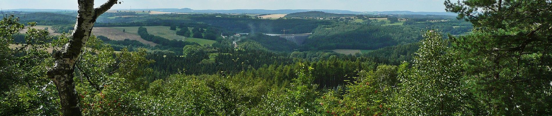
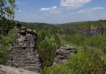
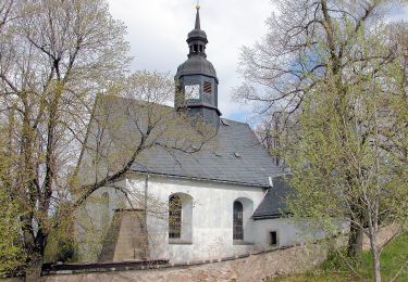
Ruta A pie de 9,5 km a descubrir en Sajonia, Sächsische Schweiz-Osterzgebirge, Bad Gottleuba-Berggießhübel. Esta ruta ha sido propuesta por SityTrail - itinéraires balisés pédestres.
Descripción
Gelber Punkt
Symbol: Gelber Punkt auf weißem Grund
Localización
País:
Germany
Región :
Sajonia
Departamento/provincia :
Sächsische Schweiz-Osterzgebirge
Municipio :
Bad Gottleuba-Berggießhübel
Localidad:
Unknown
Salida:(Dec)
Salida:(UTM)
428053 ; 5630721 (33U) N.
Comentarios
Excursiones cerca
![Excursión A pie Bad Gottleuba-Berggießhübel - [Z] okruh Oelsen - Špičák - Oelsen - Photo](https://media.geolcdn.com/t/375/260/84446251-a0ec-4b89-b1b1-9407074742c9.jpeg&format=jpg&maxdim=2)
![A pie A pie](https://static1.geolcdn.com/sitytour/trail-icons/100.png)
[Z] okruh Oelsen - Špičák - Oelsen
A pie
Fácil
Bad Gottleuba-Berggießhübel,
Sajonia,
Sächsische Schweiz-Osterzgebirge,
Germany
![](/images/other/stat-length.png)
10,5 km | 13,6 km-effort
3h 5min
![](https://static1.geolcdn.com/siteimages/upload/files/16400158638029165_repeat_loop_refresh_sync_direction_icon.png)
Sí
![Excursión A pie Bad Gottleuba-Berggießhübel - Blauer Strich - Photo](https://media.geolcdn.com/t/375/260/d63f0d81-8190-49fa-bfd5-3caa815c422b.jpeg&format=jpg&maxdim=2)
![A pie A pie](https://static1.geolcdn.com/sitytour/trail-icons/100.png)
Blauer Strich
A pie
Fácil
Bad Gottleuba-Berggießhübel,
Sajonia,
Sächsische Schweiz-Osterzgebirge,
Germany
![](/images/other/stat-length.png)
4,8 km | 6,3 km-effort
1h 26min
![](https://static1.geolcdn.com/siteimages/upload/files/16400158638029165_repeat_loop_refresh_sync_direction_icon.png)
No
![Excursión A pie Bad Gottleuba-Berggießhübel - Gelber Strich - Photo](https://media.geolcdn.com/t/375/260/d03bd92f-e437-4bb2-811b-b8e990941989.jpeg&format=jpg&maxdim=2)
![A pie A pie](https://static1.geolcdn.com/sitytour/trail-icons/100.png)
Gelber Strich
A pie
Fácil
Bad Gottleuba-Berggießhübel,
Sajonia,
Sächsische Schweiz-Osterzgebirge,
Germany
![](/images/other/stat-length.png)
4,1 km | 6,1 km-effort
1h 23min
![](https://static1.geolcdn.com/siteimages/upload/files/16400158638029165_repeat_loop_refresh_sync_direction_icon.png)
No